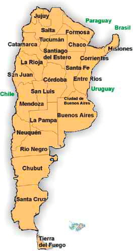
Argentina is the second largest country, by land area, in South America. It comprises 23 provinces and an autonomous city, Buenos Aires. To the north , it is bordered by Paraguay and Bolivia, no the northeast by Brazil and Uruguay , while to the west and south it’s bordered by Chile. The Andes are to the west and the Atlantic Ocean to the east.
Map of Argentina
Obviously, this is a general map of the country, highlighting its provinces. Should you plan to rent a car and explore the country on your own, then consider either downloading a recent driving map from the specialized websites or purchasing one when you get to Argentina. Also, make sure to get a map of the region you’ll be driving , as they are more detailed than general driving maps.
If you plan to do any sightseeing in
Buenos Aires , consider buying this
pocket size map of the city. Or, if you go to
Mendoza , you can get this
digital map directly on your kindle.
Photo credit